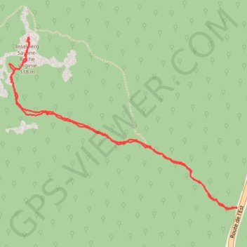
Savane roche Virginie
Randonnée pédestre. En aller-retour. #Randonnée
- Distance: 6.5 Km
- Elevation gain: 208 m
- Maximum elevation: 124 m
- Elevation loss: 208 m
- Minimum elevation: 54 m
- Moving time: 2 h 27 m
- Moving speed: 2.6 Km/h
- Maximum speed: 8.5 Km/h
- Total time: 3 h 23 m
- Global speed: 1.9 Km/h
- Date: Sunday, 13 November, 2011
Interactive map
GPS track profile
About this GPS track
Name: Savane roche Virginie GPS track, route, trail
Start: Sentier de Savane-Roche Virginie, Régina, Saint-Georges, Guyane, France (4.18452 -52.13535)
End: Sentier de Savane-Roche Virginie, Régina, Saint-Georges, Guyane, France (4.18449 -52.13543)
Coordinates: 4.18439 -52.15363 4.19812 -52.13535
Other GPS tracks
Click on a GPS track to view route, its statistics and profile.
Savane roche Virginie
Distance: 6.5 Km • Elevation gain: 203 m • Maximum elevation: 124 m