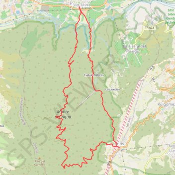
Los Silos-Los Ejos - Los Silos
Randonnée en boucle depuis Los Silos. #Randonnée #Boucle
- Distance: 16.7 Km
- Elevation gain: 1,337 m
- Maximum elevation: 1,023 m
- Elevation loss: 1,337 m
- Minimum elevation: 104 m
- Moving time: 7 h 39 m
- Moving speed: 2.2 Km/h
- Maximum speed: 7.8 Km/h
- Total time: 7 h 59 m
- Global speed: 2.1 Km/h
- Date: Friday, 12 July, 2013
Interactive map
GPS track profile
About this GPS track
Name: Los Silos-Los Ejos - Los Silos GPS track, route, trail
Coordinates: 28.32225 -16.82427 28.36526 -16.80498
Other GPS tracks
Click on a GPS track to view route, its statistics and profile.
Tenerife - Forêts vierges embrumées du Monte Del Agua
Randonnée depuis Erjos. #Randonnée
Distance: 11.5 Km • Elevation gain: 466 m • Maximum elevation: 1,028 m