Punta del Hidalgo
Sentier de Chinamada. #Randonnée
- Distance: 4.5 Km
- Elevation gain: 714 m
- Maximum elevation: 585 m
- Elevation loss: 199 m
- Minimum elevation: 12 m
Interactive map
GPS track profile
About this GPS track
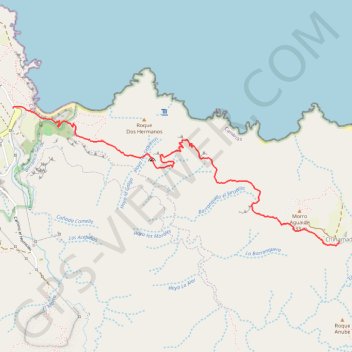
Name: Punta del Hidalgo GPS track, route, trail
Coordinates: 28.56148 -16.31834 28.57162 -16.29126
Other GPS tracks
Click on a GPS track to view route, its statistics and profile.
Carboneras - Chinamada - mirador guaide
Espagne > San Cristóbal de La Laguna > Las Carboneras
Distance: 8.0 Km • Elevation gain: 541 m • Maximum elevation: 710 m
Ten_51_Punta del Hidalgo - Batan de Abajo
Espagne > San Cristóbal de La Laguna
Distance: 12.5 Km • Elevation gain: 892 m • Maximum elevation: 593 m