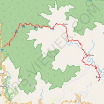
Pula - Cambulo - Batad
#Hike
- Distance: 22.1 Km
- Elevation gain: 1,717 m
- Maximum elevation: 1,816 m
- Elevation loss: 2,414 m
- Minimum elevation: 800 m
Interactive map
GPS track profile
About this GPS track
Name: Pula - Cambulo - Batad GPS track, route, trail
Coordinates: 16.93094 121.05585 16.97775 121.13716
Topography: Ifugao topographic map
Other GPS tracks
Click on a GPS track to view route, its statistics and profile.
ALTRA100
Philippines > Ifugao > Banaue > Pula
From Banaue.
Distance: 97.5 Km • Elevation gain: 8,088 m • Maximum elevation: 2,663 m