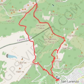
Monte Abantos, San Lorenzo del Escorial
Randonnée en boucle depuis San Lorenzo de El Escorial. #Randonnée #Boucle
- Distance: 16.3 Km
- Elevation gain: 811 m
- Maximum elevation: 1,754 m
- Elevation loss: 811 m
- Minimum elevation: 1,104 m
- Moving time: 3 h 59 m
- Moving speed: 4.1 Km/h
- Maximum speed: 6.5 Km/h
- Total time: 5 h 8 m
- Global speed: 3.2 Km/h
- Date: Thursday, 20 November, 2014
Interactive map
GPS track profile
About this GPS track
Name: Monte Abantos, San Lorenzo del Escorial GPS track, route, trail
Coordinates: 40.59411 -4.18401 40.63660 -4.15069
Other GPS tracks
Click on a GPS track to view route, its statistics and profile.
EuroVelo 1 (Spain)
Espagne > Andalousie > Côte occidentale > Ayamonte
Distance: 1,355.6 Km • Elevation gain: 14,587 m • Maximum elevation: 1,320 m
Eurovelo 01 Spain + Portugal
France > Nouvelle-Aquitaine > Pyrénées-Atlantiques > Hendaye
Distance: 3,107.2 Km • Elevation gain: 30,592 m • Maximum elevation: 1,503 m
Southern section — European Divide Trail
France > Auvergne-Rhône-Alpes > Drôme > Valence
Distance: 2,423.8 Km • Elevation gain: 42,375 m • Maximum elevation: 2,005 m
1 LUCENA - MONTPELLIER
Espagne > Andalousie > Lucena
Distance: 2,964.4 Km • Elevation gain: 29,500 m • Maximum elevation: 1,048 m
1 LUCENA - MONTPELLIER
Distance: 2,964.4 Km • Elevation gain: 29,500 m • Maximum elevation: 1,048 m
Stage 26: Valence to Saint-Jean-de-Fos — European Divide Trail
France > Auvergne-Rhône-Alpes > Drôme > Valence
Distance: 2,423.8 Km • Elevation gain: 42,375 m • Maximum elevation: 2,005 m
EuroVelo 1 (Spain)
Espagne > Andalousie > Côte occidentale > Ayamonte > Pozo del Camino > Fotea
Distance: 1,349.7 Km • Elevation gain: 13,641 m • Maximum elevation: 1,320 m