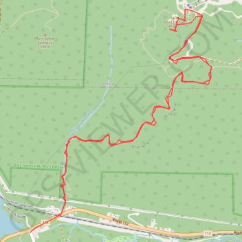
Orford, QC, sentier du ruisseau des chènes
Randonnée en aller-retour depuis Austin. #Randonnée
- Distance: 10.1 Km
- Elevation gain: 751 m
- Maximum elevation: 840 m
- Elevation loss: 749 m
- Minimum elevation: 282 m
- Moving time: 3 h 47 m
- Moving speed: 2.7 Km/h
- Maximum speed: 5.5 Km/h
- Total time: 5 h 33 m
- Global speed: 1.8 Km/h
- Date: Sunday, 09 October, 2011
Interactive map
GPS track profile
About this GPS track
Name: Orford, QC, sentier du ruisseau des chènes GPS track, route, trail
Start: Route 112, Austin, Memphrémagog, Estrie, Québec, J1X 0X4, Canada (45.29462 -72.25625)
End: Chemin North, Austin, Memphrémagog, Estrie, Québec, J1X 0X4, Canada (45.29330 -72.25939)
Coordinates: 45.29330 -72.25939 45.31262 -72.23707
Other GPS tracks
Click on a GPS track to view route, its statistics and profile.