Ostende
- Distance: 0.9 Km
- Elevation gain: 15 m
- Maximum elevation: 13 m
- Elevation loss: 21 m
- Minimum elevation: 0 m
- Moving time: 16 m 10 s
- Moving speed: 3.3 Km/h
- Maximum speed: 5.4 Km/h
- Total time: 17 m 18 s
- Global speed: 3.1 Km/h
- Date: Wednesday, 04 October, 2023
Interactive map
GPS track profile
About this GPS track
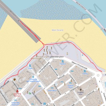
Name: Ostende GPS track, route, trail
Start: 41, Albert I-Promenade, Ostende, Flandre-Occidentale, Flandre, 8400, Belgique (51.23422 2.91532)
End: Zeeheldenplein, Ostende, Flandre-Occidentale, Flandre, 8400, Belgique (51.23474 2.92159)
Coordinates: 51.23422 2.91532 51.23679 2.92159
Other GPS tracks
Click on a GPS track to view route, its statistics and profile.
TET_B-01-NW_20230301
Pays-Bas > Brabant-Septentrional > Reusel
Distance: 447.8 Km • Elevation gain: 3,174 m • Maximum elevation: 164 m
De Bruxelles vers la mer du Nord GR
Belgique > Brabant flamand > Hal-Vilvorde > Merchtem
Randonnée entre Merchtem et Oostende. #Randonnée
Distance: 239.9 Km • Elevation gain: 669 m • Maximum elevation: 71 m
Rando Paris-Amsterdam
France > Île-de-France > Paris
Vélo. En aller simple entre Paris et Amsterdam. #Vélo
Distance: 711.6 Km • Elevation gain: 4,337 m • Maximum elevation: 247 m
Itinéraire de Hoofdweg 182III, 1057 DD Amsterdam, Pays-Bas à 9 Rue Louguet, 62100 Calais, France
Pays-Bas > Hollande-Septentrionale > Amsterdam
Distance: 356.0 Km • Elevation gain: 879 m • Maximum elevation: 21 m
Littoral
Belgique > Flandre-Occidentale > Furnes > La Panne
Distance: 65.8 Km • Elevation gain: 426 m • Maximum elevation: 22 m
TET_B-01-NW_20230301
Pays-Bas > Brabant-Septentrional > Reusel
Distance: 447.8 Km • Elevation gain: 3,174 m • Maximum elevation: 164 m