Warragul Park
Loop walk through Warragul Park. #Walk #Hike #Loop #Park #Nature #City
- Distance: 0.6 Km
- Elevation gain: 14 m
- Maximum elevation: 130 m
- Elevation loss: 14 m
- Minimum elevation: 115 m
- Moving time: 6 m 33 s
- Moving speed: 5.9 Km/h
- Maximum speed: 7.7 Km/h
- Total time: 6 m 33 s
- Global speed: 5.9 Km/h
- Date: Tuesday, 06 February, 2024
Interactive map
GPS track profile
About this GPS track
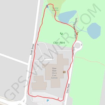
Name: Warragul Park GPS track, route, trail
Start: Albert Street, Warragul, Shire of Baw Baw, Victoria, 3820, Australia (-38.15937 145.93377)
End: Albert Street, Warragul, Shire of Baw Baw, Victoria, 3820, Australia (-38.15942 145.93373)
Coordinates: -38.15945 145.93286 -38.15719 145.93431