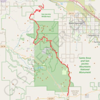
Pacific Crest Trail (PCT) through San Bernardino Forest and Santa Rosa and San Jacinto Mountains
Hike from Bull Canyon Parking to Snow Creek along the Pacific Crest National Scenic Trail via Lion Peak, Pyramid Peak, Cedar Spring, Palm View Peak, Fobes Saddle, Spitler Peak, Apache Peak, Apache Spring, Antsell Rock, South Peak, Red Tahquitz, Tahquitz Meadow, Powderbox Spring, Middle Spring, Jolley Spring, Idylwild, Deer Springs Trail and Castle Rocks in the San Bernardino National Forest and the Santa Rosa and San Jacinto Mountains National Monument. #Hike #PCT #Nature #Mountain #Forest
- Distance: 95.0 Km
- Elevation gain: 3,982 m
- Maximum elevation: 2,737 m
- Elevation loss: 5,104 m
- Minimum elevation: 376 m
- Moving time: 1 d 5 h
- Moving speed: 3.2 Km/h
- Maximum speed: 5.6 Km/h
- Total time: 5 d 1 m
- Global speed: 0.8 Km/h
- Date: Thursday, 14 November, 2019
Interactive map
GPS track profile
About this GPS track
Name: Pacific Crest Trail (PCT) through San Bernardino Forest and Santa Rosa and San Jacinto Mountains GPS track, route, trail
Start: Bull Canyon Parking, Riverside County, California, United States (33.56322 -116.57671)
Coordinates: 33.56322 -116.74010 33.89376 -116.56198
Other GPS tracks
Click on a GPS track to view route, its statistics and profile.
Suicide Rock
United States > California > Riverside County > Idyllwild-Pine Cove
Hike from Idyllwild Nature Center to Suicide Rock via Deer Springs Trail and Suicide Rock Trail in the San Bernardino National Forest and the Mount San Jacinto State Wilderness. #Hike #Mountain #Nature #Forest #Wilderness
Distance: 12.0 Km • Elevation gain: 638 m • Maximum elevation: 2,262 m
Cactus to Clouds
United States > California > Riverside County > Palm Springs
Hike from Palm Springs to San Jacinto Peak by the Skyline Trail, the Grubbs Notch, the Round Valley Trail, the Wellman Divide and the Peak Trail in the Santa Rosa and San Jacinto Mountains National Monument. #Hike #Mountain #Nature #Forest #Park
Distance: 31.6 Km • Elevation gain: 3,298 m • Maximum elevation: 3,280 m
San Jacinto - Cactus to clouds
États-Unis d'Amérique > Californie > Riverside County > Palm Springs
Randonnée pédestre. Depuis Palm Springs. #Randonnée
Distance: 29.9 Km • Elevation gain: 3,261 m • Maximum elevation: 3,279 m
Mount Jacinto Loop
United States > California > Riverside County > Idyllwild-Pine Cove
Loop Hike to Mount Jacinto via Deer Springs Trail, Pacific Crest Trail (PCT), Peak Trail and Wellman's Cienaga Trail in the San Bernardino National Forest and the Mount San Jacinto State Park. #Hike #Loop #Mountain #Nature #Forest #Park #PCT
Distance: 28.0 Km • Elevation gain: 1,646 m • Maximum elevation: 3,279 m
Suicide Rock
United States > California > Riverside County > Idyllwild-Pine Cove
Hike to Suicide Rock by the Deer Springs Trail and the Suicide Rock Trail in the San Bernardino National Forest and the Mount San Jacinto State Wilderness. #Hike #Mountain #Nature #Forest #Wilderness
Distance: 5.4 Km • Elevation gain: 568 m • Maximum elevation: 2,265 m