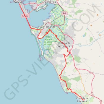
01: Cadix et son réseau cyclable en bord de mer – Conil de la Frontera (DEVELOPED)
DEVELOPED
- Distance: 52.8 Km
- Elevation gain: 244 m
- Maximum elevation: 46 m
- Elevation loss: 237 m
- Minimum elevation: 0 m
Interactive map
GPS track profile
About this GPS track
Name: 01: Cadix et son réseau cyclable en bord de mer – Conil de la Frontera (DEVELOPED) GPS track, route, trail
Coordinates: 36.27603 -6.28781 36.52321 -6.08031
Other GPS tracks
Click on a GPS track to view route, its statistics and profile.
Southern Section — European Divide Trail
Espagne > Andalousie > Cazorla
Distance: 830.4 Km • Elevation gain: 19,253 m • Maximum elevation: 2,134 m
Vila do Bispo -> Distrito 4 (500,7 km)
Distance: 495.9 Km • Elevation gain: 3,232 m • Maximum elevation: 165 m
Vila do Bispo -> Distrito 4 (495,2 km)
Distance: 1,306.4 Km • Elevation gain: 23,128 m • Maximum elevation: 2,134 m
Vila do Bispo -> Distrito 4 (483,3 km)
Distance: 480.3 Km • Elevation gain: 2,998 m • Maximum elevation: 182 m
Vila do Bispo -> Distrito 4 (604,8 km)
Distance: 601.5 Km • Elevation gain: 2,944 m • Maximum elevation: 106 m