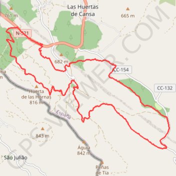
Rando - El Pino
Randonnée en boucle depuis Valencia de Alcántara. #Randonnée #Boucle
- Distance: 19.6 Km
- Elevation gain: 509 m
- Maximum elevation: 781 m
- Elevation loss: 509 m
- Minimum elevation: 572 m
- Moving time: 4 h 38 m
- Moving speed: 4.2 Km/h
- Maximum speed: 6.8 Km/h
- Total time: 7 h 8 m
- Global speed: 2.8 Km/h
- Date: Monday, 18 April, 2011
Interactive map
GPS track profile
About this GPS track
Name: Rando - El Pino GPS track, route, trail
Coordinates: 39.31272 -7.30336 39.34710 -7.24374
Other GPS tracks
Click on a GPS track to view route, its statistics and profile.
Southern section — European Divide Trail
France > Auvergne-Rhône-Alpes > Drôme > Valence
Distance: 2,423.8 Km • Elevation gain: 42,375 m • Maximum elevation: 2,005 m
EuroVelo 1 (Spain)
Espagne > Andalousie > Côte occidentale > Ayamonte
Distance: 1,355.6 Km • Elevation gain: 14,587 m • Maximum elevation: 1,320 m
Eurovelo 01 Spain + Portugal
France > Nouvelle-Aquitaine > Pyrénées-Atlantiques > Hendaye
Distance: 3,107.2 Km • Elevation gain: 30,592 m • Maximum elevation: 1,503 m
Stage 26: Valence to Saint-Jean-de-Fos — European Divide Trail
France > Auvergne-Rhône-Alpes > Drôme > Valence
Distance: 2,423.8 Km • Elevation gain: 42,375 m • Maximum elevation: 2,005 m
EuroVelo 1 (Spain)
Espagne > Andalousie > Côte occidentale > Ayamonte > Pozo del Camino > Fotea
Distance: 1,349.7 Km • Elevation gain: 13,641 m • Maximum elevation: 1,320 m
LLOR2022_Final_10K_CP
Portugal > Faro > Vila Real de Santo António > Monte Gordo
Distance: 946.0 Km • Elevation gain: 20,227 m • Maximum elevation: 1,130 m