Projet__cosse_munro(1)
- Distance: 200.2 Km
- Elevation gain: 13,435 m
- Maximum elevation: 1,097 m
- Elevation loss: 13,456 m
- Minimum elevation: 4 m
Interactive map
GPS track profile
About this GPS track
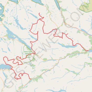
Name: Projet__cosse_munro(1) GPS track, route, trail
Start: Lochluichart, Highland, Écosse, IV23 2PZ, Royaume-Uni (57.62183 -4.80848)
End: A890, Highland, Écosse, IV54 8YU, Royaume-Uni (57.48201 -5.33356)
Coordinates: 57.48128 -5.58438 57.80713 -4.80640
Other GPS tracks
Click on a GPS track to view route, its statistics and profile.
Inverewe and Great Wilderness
United Kingdom > Scotland > Highland > Poolewe
Distance: 15.6 Km • Elevation gain: 308 m • Maximum elevation: 47 m
Beinn Eighe Mountain Trail
United Kingdom > Scotland > Highland
Distance: 6.4 Km • Elevation gain: 553 m • Maximum elevation: 555 m