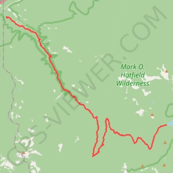
Eagle Creek and Falls
Hike from Columbia River to the Wahtum Lake along Eagle Creek via Metlako Falls, Sorenson Falls, Punch Bowl Falls, Four Mile Falls, Wy east Falls, Grand Union Falls, Tunnel Falls and Twister Falls in the Mark O. Hatfield Wilderness. #Hike #River #Falls #Canyon #Forest #Mountain #Lake #Wilderness
- Distance: 21.1 Km
- Elevation gain: 1,778 m
- Maximum elevation: 1,144 m
- Elevation loss: 681 m
- Minimum elevation: 42 m
Interactive map
GPS track profile
About this GPS track
Name: Eagle Creek and Falls GPS track, route, trail
End: Chindere Cutoff Trail #406M, Hood River County, Oregon, United States (45.58111 -121.80109)
Coordinates: 45.56448 -121.91966 45.63727 -121.80097
Other GPS tracks
Click on a GPS track to view route, its statistics and profile.
Northern part of the Pacific Crest Trail (PCT)
United States > Oregon > Klamath County
Hike on the Pacific Crest National Scenic Trail from Crater Lake to Canada Border through Oregon and Washington along the Sierra Nevada and Cascade mountain ranges. #Hike #Mountain #SierraNevada #Cascade #Nature #Forest #Park #PCT
Distance: 1,198.3 Km • Elevation gain: 44,308 m • Maximum elevation: 2,307 m
Cascade Locks - Sisters
États-Unis d'Amérique > Oregon > Hood River County > Cascade Locks
Vélo. En aller simple entre Cascade Locks et Sisters. #Vélo
Distance: 320.2 Km • Elevation gain: 5,945 m • Maximum elevation: 1,470 m