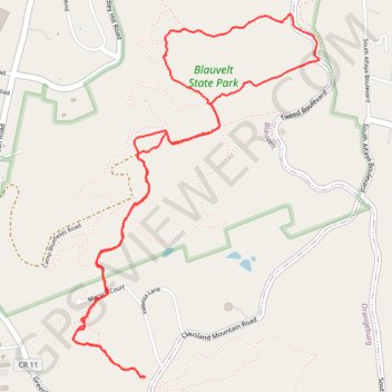
Hike at Oh Five, Red and White Loop via Long Path
Loop hike in Blauvelt State Park. #Hike #Loop #Nature #Forest #Park
- Distance: 6.8 Km
- Elevation gain: 151 m
- Maximum elevation: 187 m
- Elevation loss: 151 m
- Minimum elevation: 76 m
- Moving time: 1 h 45 m
- Moving speed: 3.9 Km/h
- Maximum speed: 8.9 Km/h
- Total time: 2 h 9 m
- Global speed: 3.1 Km/h
- Date: Monday, 08 April, 2024
Interactive map
GPS track profile
About this GPS track
Name: Hike at Oh Five, Red and White Loop via Long Path GPS track, route, trail
Coordinates: 41.06253 -73.94405 41.07848 -73.92971
Other GPS tracks
Click on a GPS track to view route, its statistics and profile.
Montréal - New York
Canada > Québec > Agglomération de Montréal > Montréal
Distance: 637.3 Km • Elevation gain: 4,134 m • Maximum elevation: 301 m