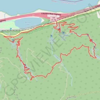
Multnomah Falls, Ecola Falls and Wahkeena Falls Loop
Loop hike via Larch Mountain Trail, Benson Bridge, Lower Multnomah Falls, Dutchman Falls, Wiesendanger Falls, Ecola Falls, Wahkeena Trail, Fairy Falls, Lemmons Viewpoint, Wahkeena Falls and Return Trail in the Mount Hood National Forest above the Benson Lake and the Columbia River. #Hike #Loop #Falls #River #Nature #Mountain #Forest #Lake
- Distance: 9.2 Km
- Elevation gain: 1,042 m
- Maximum elevation: 506 m
- Elevation loss: 1,025 m
- Minimum elevation: 12 m
- Moving time: 2 h 46 m
- Moving speed: 3.3 Km/h
- Maximum speed: 12.3 Km/h
- Total time: 3 h 13 m
- Global speed: 2.9 Km/h
- Date: Saturday, 25 June, 2022
Interactive map
GPS track profile
About this GPS track
Name: Multnomah Falls, Ecola Falls and Wahkeena Falls Loop GPS track, route, trail
Start: Columbia River Highway, Multnomah County, Oregon, 97010, United States (45.57823 -122.11720)
End: Larch Mountain Trail #441, Multnomah County, Oregon, 97010, United States (45.57766 -122.11719)
Coordinates: 45.56780 -122.12989 45.57823 -122.10701
Other GPS tracks
Click on a GPS track to view route, its statistics and profile.
Northern part of the Pacific Crest Trail (PCT)
United States > Oregon > Klamath County
Hike on the Pacific Crest National Scenic Trail from Crater Lake to Canada Border through Oregon and Washington along the Sierra Nevada and Cascade mountain ranges. #Hike #Mountain #SierraNevada #Cascade #Nature #Forest #Park #PCT
Distance: 1,198.3 Km • Elevation gain: 44,308 m • Maximum elevation: 2,307 m
Cascade Locks - Sisters
États-Unis d'Amérique > Oregon > Hood River County > Cascade Locks
Vélo. En aller simple entre Cascade Locks et Sisters. #Vélo
Distance: 320.2 Km • Elevation gain: 5,945 m • Maximum elevation: 1,470 m