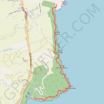
Randonnée du littoral de l'anse des cascades (Réunion)
Randonnée pédestre. En aller-retour. #Randonnée #Réunion #Île #Mer
- Distance: 7.8 Km
- Elevation gain: 226 m
- Maximum elevation: 34 m
- Elevation loss: 228 m
- Minimum elevation: 1 m
- Moving time: 2 h 26 m
- Moving speed: 3.2 Km/h
- Maximum speed: 9.0 Km/h
- Total time: 4 h 40 m
- Global speed: 1.7 Km/h
- Date: Wednesday, 16 September, 2015
Interactive map
GPS track profile
About this GPS track
Name: Randonnée du littoral de l'anse des cascades (Réunion) GPS track, route, trail
Coordinates: -21.18612 55.82759 -21.16384 55.83655
Other GPS tracks
Click on a GPS track to view route, its statistics and profile.
Sentier litoral de Sainte Rose - Anse des Cascades
France > La Réunion > Sainte-Rose
Distance: 4.3 Km • Elevation gain: 124 m • Maximum elevation: 34 m