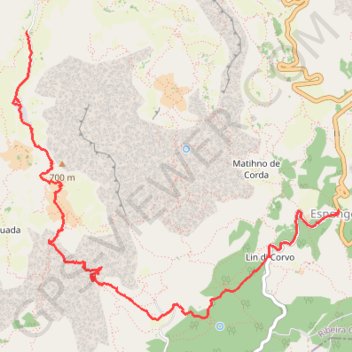
Cap vert - Cha de Pedra - Espongeiro
Randonnée pédestre. En aller simple. #Randonnée
- Distance: 9.1 Km
- Elevation gain: 1,312 m
- Maximum elevation: 1,368 m
- Elevation loss: 259 m
- Minimum elevation: 306 m
- Moving time: 3 h 33 m
- Moving speed: 2.6 Km/h
- Maximum speed: 13.9 Km/h
- Total time: 6 h 24 m
- Global speed: 1.4 Km/h
- Date: Saturday, 11 April, 2015
Interactive map
GPS track profile
About this GPS track
Name: Cap vert - Cha de Pedra - Espongeiro GPS track, route, trail
Start: Pia de Cima, Ribeirão, Ribeira Grande, 1139, Cap-Vert (17.13222 -25.11272)
End: EN3-SA-08, Lin d' Corvo, Espongeiro, Ribeira Grande, 1310, Cap-Vert (17.11539 -25.08265)
Coordinates: 17.10560 -25.11411 17.13222 -25.08257
Other GPS tracks
Click on a GPS track to view route, its statistics and profile.
Patrice_FIVEL_2024-03-11_08-00-07
Cap-Vert > São Vicente > Mindelo
Distance: 39.6 Km • Elevation gain: 1,601 m • Maximum elevation: 1,446 m
Essai_11km
Cap-Vert > Ribeira Grande > Espongeiro > Lin d' Corvo
Distance: 11.1 Km • Elevation gain: 857 m • Maximum elevation: 1,343 m
Mon_parcour55555555555
Cap-Vert > Ribeira Grande > Ribeirão > Boca de João Afonso
Distance: 6.7 Km • Elevation gain: 1,169 m • Maximum elevation: 1,330 m