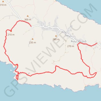
Le phare de Folegandros et Livadaki
Randonnée pédestre. En aller simple. #Randonnée
- Distance: 9.5 Km
- Elevation gain: 557 m
- Maximum elevation: 257 m
- Elevation loss: 546 m
- Minimum elevation: 3 m
- Moving time: 3 h 12 m
- Moving speed: 3.0 Km/h
- Maximum speed: 5.3 Km/h
- Total time: 4 h 35 m
- Global speed: 2.1 Km/h
- Date: Monday, 15 July, 2013
Interactive map
GPS track profile
About this GPS track
Name: Le phare de Folegandros et Livadaki GPS track, route, trail
Coordinates: 36.63226 24.85500 36.64972 24.88919
Other GPS tracks
Click on a GPS track to view route, its statistics and profile.