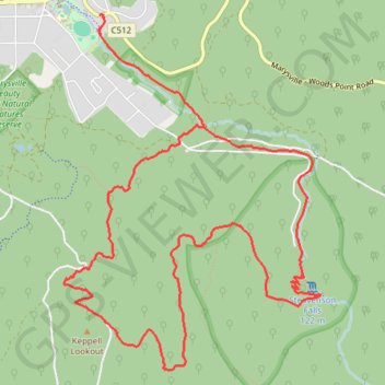
Marysville Loop
Steavensons Falls Natural Features and Scenic Reserve. #Hike #Loop #Steavensons
- Distance: 13.6 Km
- Elevation gain: 588 m
- Maximum elevation: 837 m
- Elevation loss: 590 m
- Minimum elevation: 426 m
Interactive map
GPS track profile
About this GPS track
Name: Marysville Loop GPS track, route, trail
Start: Woods Point Road, Marysville, Shire of Murrindindi, Victoria, 3779, Australia (-37.51150 145.75321)
End: Woods Point Road, Marysville, Shire of Murrindindi, Victoria, 3779, Australia (-37.51155 145.75291)
Coordinates: -37.53963 145.74935 -37.51150 145.77494
Other GPS tracks
Click on a GPS track to view route, its statistics and profile.
Tallarook - Eildon - Hurstbridge
Australia > Victoria > Tallarook
#Bike
Distance: 278.8 Km • Elevation gain: 4,897 m • Maximum elevation: 868 m