Bukit Timah Nature Reserve
Interactive map
GPS track profile
About this GPS track
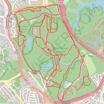
Name: Bukit Timah Nature Reserve GPS track, route, trail
Start: Hindhede Drive, Bukit Panjang, Singapore, Northwest, 589242, Singapore (1.34758 103.77640)
End: Hindhede Drive, Bukit Panjang, Singapore, Northwest, 589242, Singapore (1.34740 103.77628)
Coordinates: 1.34285 103.76835 1.36514 103.78645
Other GPS tracks
Click on a GPS track to view route, its statistics and profile.
Bukit Timah Hill - MacRitchie Reservoir
Singapore > Southwest > Singapore
#Hike
Distance: 14.8 Km • Elevation gain: 290 m • Maximum elevation: 167 m
The Green Corridor - Singapore
Singapore > Northwest > Singapore
#Hike
Distance: 22.3 Km • Elevation gain: 167 m • Maximum elevation: 44 m
Directions from Duck Tour Ramp to Marina Boulevard, Singapore
Singapore > Central > Singapore
Distance: 105.3 Km • Elevation gain: 812 m • Maximum elevation: 51 m
Kualanamu International Airport to Jakarta, Indonesia
Indonésie > Sumatra du Nord > Deli Serdang > Beringin
Distance: 1,809.2 Km • Elevation gain: 10,977 m • Maximum elevation: 125 m