Trail Planner Map
- Distance: 20.3 Km
- Elevation gain: 1,151 m
- Maximum elevation: 423 m
- Elevation loss: 1,184 m
- Minimum elevation: 7 m
Interactive map
GPS track profile
About this GPS track
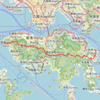
Name: Trail Planner Map GPS track, route, trail
End: Siu Sai Wan, Eastern District, Hong Kong Island, Hong Kong, China (22.26460 114.25241)
Coordinates: 22.25294 114.11772 22.27763 114.25411
Other GPS tracks
Click on a GPS track to view route, its statistics and profile.
雙潭渣大
China > Hong Kong > Hong Kong Island
Distance: 6.8 Km • Elevation gain: 353 m • Maximum elevation: 305 m
Wilson Trail
China > Hong Kong > Hong Kong Island
#Hike
Distance: 13.1 Km • Elevation gain: 1,032 m • Maximum elevation: 410 m
金馬倫北坑 金馬倫西坑
China > Hong Kong > Hong Kong Island
Distance: 4.0 Km • Elevation gain: 340 m • Maximum elevation: 399 m
HK dino
China > Hong Kong > Hong Kong Island
Loop hike from Kennedy Town via Lung Fu Shan, High West, Victoria Peak, Pok Fu Lam Reservoir and Mount Davis in the Lung Fu Shan Country Park and the Pok Fu Lam Country Park. #Hike #Loop #Nature #Mountain #Forest #Sea #Pacific #Ocean #Park
Distance: 24.4 Km • Elevation gain: 1,325 m • Maximum elevation: 529 m
Hong Kong island ride
China > Hong Kong > Hong Kong Island
#Bike
Distance: 61.8 Km • Elevation gain: 2,152 m • Maximum elevation: 505 m
Wilson Trail Full Route
China > Hong Kong > Hong Kong Island
Distance: 81.2 Km • Elevation gain: 4,430 m • Maximum elevation: 613 m
Jardine's Lookout
China > Hong Kong > Hong Kong Island
#Hike
Distance: 6.1 Km • Elevation gain: 350 m • Maximum elevation: 410 m
Parview - Mont Butler - Reservoirs - Repulse Bay
Chine > Hong Kong > Île de Hong Kong
Randonnée pédestre. En aller simple. #Randonnée
Distance: 8.4 Km • Elevation gain: 382 m • Maximum elevation: 410 m
Central Hong Kong - Pok Fu Lam Country Park
China > Hong Kong > Hong Kong Island
#Hike
Distance: 7.4 Km • Elevation gain: 431 m • Maximum elevation: 401 m