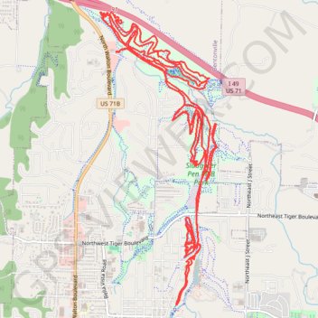
Slaughter Pen MTB Loops
Mountain Bike loops at Slaughter Pen along Town Branch Creek. #MTB #Loop #Forest #River #Nature
- Distance: 27.7 Km
- Elevation gain: 502 m
- Maximum elevation: 385 m
- Elevation loss: 502 m
- Minimum elevation: 325 m
- Moving time: 9 h 59 m
- Moving speed: 2.8 Km/h
- Maximum speed: 12.9 Km/h
- Total time: 10 h 57 m
- Global speed: 2.5 Km/h
- Date: Monday, 20 June, 2016
Interactive map
GPS track profile
About this GPS track
Name: Slaughter Pen MTB Loops GPS track, route, trail
Start: Northwest A Street, Bentonville, Benton County, Arkansas, 72712, United States (36.40836 -94.21533)
End: Northwest A Street, Bentonville, Benton County, Arkansas, 72712, United States (36.40833 -94.21530)
Coordinates: 36.37881 -94.21758 36.41298 -94.20058
Other GPS tracks
Click on a GPS track to view route, its statistics and profile.
2024-05-06 08:14
United States > Missouri > Barry County
File with points/tracks from Locus Map Classic/3.70.9
Distance: 179.4 Km • Elevation gain: 1,577 m • Maximum elevation: 499 m